


Tóm Tắt Nội Dung Bài Viết
The reading passage Air Conditioning the Earth analyzes how the Earth’s atmosphere operates like a colossal planetary air conditioner through convection, atmospheric circulation, and the poleward transfer of heat. The text not only explains the mechanics behind climate zones and weather fronts but also highlights the crucial role of wind systems in maritime history. This test challenges candidates through three distinct question types: Diagram Labelling, Summary Completion with a Box, and Classification. Join the ECE Language Center as we explore this fascinating reading passage.
Reading Passage
Air conditioning the earth
[Paragraph 1] The circulation of air in the atmosphere is activated by convection, the transference of heat resulting from the fact that warm gases or fluids rise while cold gases or fluids sink. For example, if one wall of a room is heated whilst the opposite wall is cooled, air will rise against the warm wall and flow across the ceiling to the cold wall before descending to flow back across the floor to the warm wall again. The real atmosphere, however, is like a very long room with a very low ceiling.
[Paragraph 2] The distance from equator to pole is 10,000 km, while the ‘ceiling height’ to the beginning of the stratosphere is only about 10 km. The air therefore splits up into a number of smaller loops or convection cells. Between the equator and each pole there are three such cells and within these the circulation is mainly north-south.
Large-scale air-conditioning
[Paragraph 3] The result of this circulation is a flow of heat energy towards the poles and a leveling out of the climate so that both equatorial and polar regions are habitable. The atmosphere generally retains its state of equilibrium as every north-going air current is counterbalanced by a south-going one. In the same way depressions at lower levels in the troposphere are counterbalanced by areas of high pressure in the upper levels, and vice versa. The atmospheric transference of heat is closely associated with the movement of moisture between sea and continent and between different latitudes. Moist air can transport much greater quantities of energy than dry air.
[Paragraph 4] Because the belts of convection cells run east to west, both climate and weather vary according to latitude. Climatic zones are particularly distinguishable at sea where there are no land masses to disturb the pattern.
Man and the winds
[Paragraph 5] For thousands of years mankind has been dependent upon the winds: they brought rain to the land and carried ships across the seas. Thus the westerly wind belts, the trade winds and the monsoon winds of the global circulation systems have been known to us for many centuries.
[Paragraph 6] As recently as the 20th century, Arab ships sailed on the south-west monsoon winds from East Africa to India and back again on the north-east monsoon winds, without need of a compass. The winds alone were sufficient. In the equatorial convergence zone (the ‘doldrums’), and in the regions around the Tropic of Cancer and Tropic of Capricorn known as the ‘horse latitudes’, sailing ships could drift for weeks unable to steer, while the ‘roaring forties’ of the South Atlantic (40-50°S) were notorious among mariners for their terrible winds.
[Paragraph 7] It was not until the development of the balloon at the end of the 18th century, however, that it became possible to study meteorological conditions at high altitudes. The balloon is still a significant research device although today it carries a radar reflector or a set of instruments and a radio transmitter, rather than the scientists themselves. Nowadays high-flying aircraft and satellites are also important aids to meteorology. Through them we have discovered the west to east jet stream. This blows at speeds of up to 500 km/h at altitudes of 9,000-10,000 m along the border between the Arctic and temperate zone convection belts.
Weather fronts
[Paragraph 8] The circulation within the different convection cells is greater than the exchange of air between them and therefore the temperature in two cells that are close to each other can differ greatly. Consequently, the borders between the different convection cells are areas in which warm and cold air masses oppose each other, advancing and withdrawing. In the Northern Hemisphere, the dividing line between the Arctic and temperate convection zones is the polar front, and it is this which determines the weather in northern Europe and North America. This front is unstable, weaving sometimes northward, sometimes southward, of an average latitude of 60°N. Depressions become trapped within the deep concavities of this front and these subsequently move eastward along it with areas of rain and snowfall. In this way global air circulation determines not only the long-term climate but also the immediate weather.
Questions
Questions 1–3: Diagram Labelling
Label the diagram below.
Choose NO MORE THAN TWO WORDS AND/OR A NUMBER from the passage for each answer.
Write your answers in boxes 1–3 on your answer sheet.
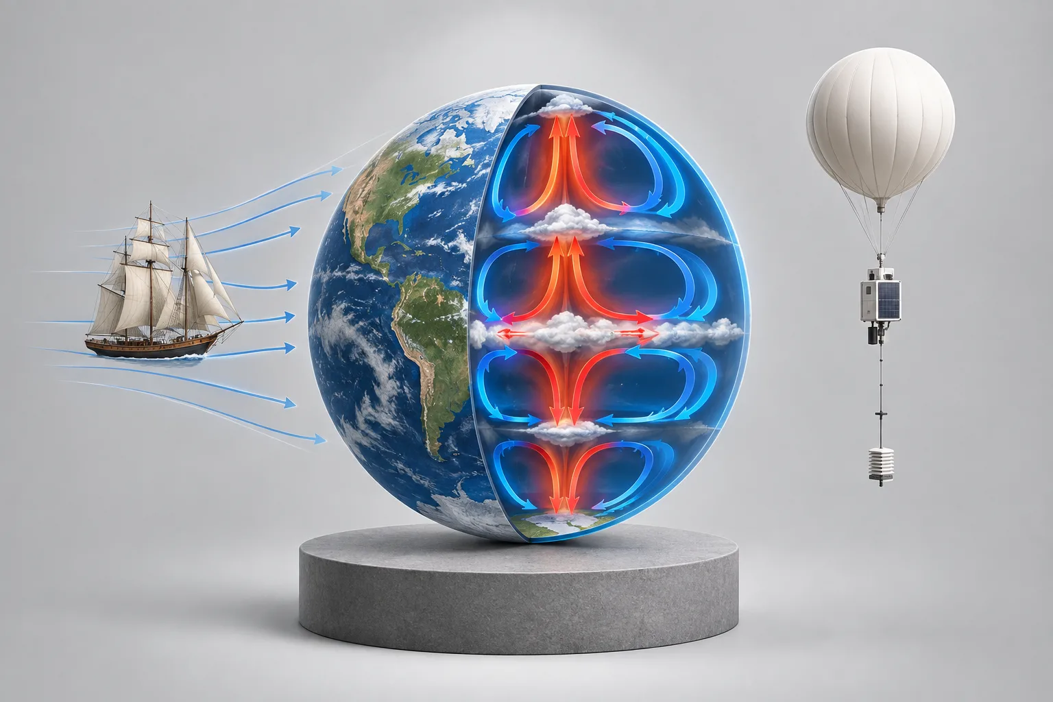
(Atmospheric cross-section diagram illustrating convective circulation from the equator to the poles)
1. Distance from the North Pole to the equator: _______________
2. Ceiling height to the beginning of the stratosphere: _______________
3. Smaller loops into which the air splits up: _______________
Questions 4–7: Summary Completion with a Box
Complete the summary below using the list of words and phrases, A–L, below.
Write the appropriate letter, A–L, in boxes 4–7 on your answer sheet.
List of Words and Phrases:
A. on land
B. polar regions
C. moisture
D. heat
E. balanced
F. at sea
G. offset
H. pole
I. equatorial regions
J. latitude
K. in the air
L. longitude
Global air circulation spreads heat from the equator towards the 4. _______________. Generally, a state of balance in the atmosphere is maintained because the north-moving air currents are continually being 5. _______________ by the south ones. Within the system of heat transfer in the atmosphere, the climate is affected not only by 6. _______________ but also by the amount of moisture in the air. The most accurate geographical zone for the study of climate is 7. _______________, where there are no local wind systems.
Questions 8–12: Classification
Classify the following wind patterns according to whether the writer states they are:
A. useful
B. problematic
C. neither useful nor problematic
Write the correct letter, A, B, or C, in boxes 8–12 on your answer sheet.
8. ‘roaring forties’
9. south-west monsoon winds
10. west to east jet stream
11. ’horse latitudes’
12. north-east monsoon winds
Question 13: Short Answer Question
Answer the question below.
Choose NO MORE THAN THREE WORDS AND/OR A NUMBER from the passage.
Write your answer in box 13 on your answer sheet.
Which border between convection zones determines the weather in the Northern Hemisphere?
13. _______________
Complete Vietnamese Translation of the Reading Passage
[Paragraph 1] The circulation of air in the atmosphere is activated by convection, the transference of heat resulting from the fact that warm gases or fluids rise while cold gases or fluids sink. For example, if one wall of a room is heated whilst the opposite wall is cooled, air will rise against the warm wall and flow across the ceiling to the cold wall before descending to flow back across the floor to the warm wall again. The real atmosphere, however, is like a very long room with a very low ceiling.
[Paragraph 2] The distance from equator to pole is 10,000 km, while the ‘ceiling height’ to the beginning of the stratosphere is only about 10 km. The air therefore splits up into a number of smaller loops or convection cells. Between the equator and each pole there are three such cells and within these the circulation is mainly north-south.
[Paragraph 3] The result of this circulation is a flow of heat energy towards the poles and a leveling out of the climate so that both equatorial and polar regions are habitable. The atmosphere generally retains its state of equilibrium as every north-going air current is counterbalanced by a south-going one. In the same way depressions at lower levels in the troposphere are counterbalanced by areas of high pressure in the upper levels, and vice versa. The atmospheric transference of heat is closely associated with the movement of moisture between sea and continent and between different latitudes. Moist air can transport much greater quantities of energy than dry air.
[Paragraph 4] Because the belts of convection cells run east to west, both climate and weather vary according to latitude. Climatic zones are particularly distinguishable at sea where there are no land masses to disturb the pattern.
[Paragraph 5] For thousands of years mankind has been dependent upon the winds: they brought rain to the land and carried ships across the seas. Thus the westerly wind belts, the trade winds and the monsoon winds of the global circulation systems have been known to us for many centuries.
[Paragraph 6] As recently as the 20th century, Arab ships sailed on the south-west monsoon winds from East Africa to India and back again on the north-east monsoon winds, without need of a compass. The winds alone were sufficient. In the equatorial convergence zone (the ‘doldrums’), and in the regions around the Tropic of Cancer and Tropic of Capricorn known as the ‘horse latitudes’, sailing ships could drift for weeks unable to steer, while the ‘roaring forties’ of the South Atlantic (40-50°S) were notorious among mariners for their terrible winds.
[Paragraph 7] It was not until the development of the balloon at the end of the 18th century, however, that it became possible to study meteorological conditions at high altitudes. The balloon is still a significant research device although today it carries a radar reflector or a set of instruments and a radio transmitter, rather than the scientists themselves. Nowadays high-flying aircraft and satellites are also important aids to meteorology. Through them we have discovered the west to east jet stream. This blows at speeds of up to 500 km/h at altitudes of 9,000-10,000 m along the border between the Arctic and temperate zone convection belts.
[Paragraph 8] The circulation within the different convection cells is greater than the exchange of air between them and therefore the temperature in two cells that are close to each other can differ greatly. Consequently, the borders between the different convection cells are areas in which warm and cold air masses oppose each other, advancing and withdrawing. In the Northern Hemisphere, the dividing line between the Arctic and temperate convection zones is the polar front, and it is this which determines the weather in northern Europe and North America. This front is unstable, weaving sometimes northward, sometimes southward, of an average latitude of 60°N. Depressions become trapped within the deep concavities of this front and these subsequently move eastward along it with areas of rain and snowfall. In this way global air circulation determines not only the long-term climate but also the immediate weather.
Academic Vocabulary
-
Atmospheric circulation (n): The movement of air across the Earth’s atmosphere.
-
Convection cell (n): A self-contained convective loop in the atmosphere or ocean.
-
Stratosphere / Troposphere (n): Layers of the Earth’s atmosphere.
-
State of equilibrium (phrase): A dynamic state of balance.
-
Counterbalance / Offset (v): To balance out or neutralize opposing forces.
-
Depression (meteorology) (n): A region of low atmospheric pressure.
-
Trade winds / Monsoon winds (n): Prevailing and seasonal wind systems.
-
Equatorial convergence zone / Doldrums (n): A belt of calm and erratic winds near the equator.
-
Jet stream (n): A fast-flowing, narrow air current in the upper atmosphere.
-
Polar front (n): The boundary separating cold polar air from warm temperate air.
Answer Key & Explanations: Air Conditioning the Earth
Questions 1–3: Diagram Labelling
1. Answer: 10,000 km / 10,000 kilometers
Passage reference in Paragraph 2: “The distance from equator to pole is 10,000 km…”
Analysis: The distance from the pole to the equator is explicitly stated as 10,000 km.
2. Answer: 10 km / 10 kilometers
Passage reference in Paragraph 2: “…while the ‘ceiling height’ to the beginning of the stratosphere is only about 10 km.”
Analysis: The ceiling height to the start of the stratosphere is roughly 10 km.
3. Answer: convection cells / smaller loops
Passage reference in Paragraph 2: “The air therefore splits up into a number of smaller loops or convection cells.”
Analysis: Air divides into smaller loops known as convection cells.
Questions 4–7: Summary Completion with a Box
4. Answer: B (polar regions)
Passage reference in Paragraph 3: “The result of this circulation is a flow of heat energy towards the poles and a leveling out of the climate so that both equatorial and polar regions are habitable.”
Analysis: Global air circulation carries heat energy from the equator toward the poles (towards the polar regions).
5. Answer: G (offset) or E (balanced)
Passage reference in Paragraph 3: “The atmosphere generally retains its state of equilibrium as every north-going air current is counterbalanced by a south-going one.”
Analysis: Northward-moving air currents are continually offset or balanced by southward-moving ones (counterbalanced matches offset or balanced).
6. Answer: J (latitude)
Passage reference in Paragraphs 3 & 4: “The atmospheric transference of heat is closely associated with the movement of moisture between sea and continent and between different latitudes… both climate and weather vary according to latitude.”
Analysis: Climate is influenced not only by atmospheric moisture but also by latitude (corresponding to letter J).
7. Answer: F (at sea)
<p



 Khai giảng Khóa học Hè cực HOT.
No comments yet!